Out and about: Green as far as the eye can see along the Barbershop Trail
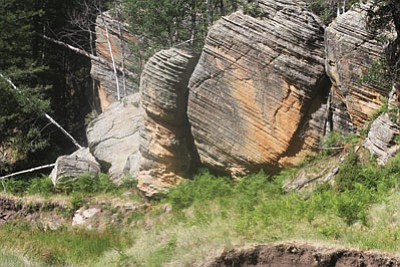
Interesting boulders show up in Dane Canyon along the Barbershop Trail. Photo/Stan Bindell
PAYSON, Ariz. - Ferns are plentiful on northern Arizona trails, but this hiker has never seen a stand of ferns to equal the ferns at the beginning of the Barbershop Trail. These ferns look like the type of overgrown green forest where Dorothy in "The Wizard of Oz" could get lost.
Some of these ferns rise up over five feet. Maybe these plants think they are trees. This was before most of this summer's rains, but yet the sunflowers were starting to bloom and the orange butterflies were posing for photos.
The good news is there are many drainages along this trail, but few had water before the rains. This is also one of the toughest trails to follow.
Arizona Highways ranks the nine mile trail as moderate, but there are some hills to cause huffing and puffing. We were able to stay on the trail for about three miles, but after that it was lost and we'd have to find the rest of the trail on another day.
The Barbershop Trail starts at 7,603 feet, which means cool summer temperatures, and only goes up to 7,811 feet, but be prepared for the many ups and downs along the way.
One of the highlights of the trail is Dane Canyon where some entertaining boulders were found. But Dane Canyon was dry. It's easy to imagine that Dane Canyon would be picturesque with water.
According to Arizona Highways, Barbershop Trail was named for a sheepherder who cut people's hair as well as the sheep's wool. It makes me wonder if my barber could cut sheep's wool.
As we were pulling up on the last Forest Service road to the trailhead, a wild turkey with its chick was on the side of the road. It didn't stick around to pose, but seemed happy in its environment. Mule deer, elk and black bears are also known to frequent this area.
The trail starts with shade provided by ponderosa pines. Aspens, oaks and maples are found later on the trail making this a beautiful hike in the fall when the leaves change colors.
The ponderosa pines soon make way for the fern forest. Then the ponderosas pop up again to provide more shade.
About two miles into the hike, Dane Canyon appears. After that, hikers come down a slope and into a meadow. This is where one of the tricky spots to follow the trail occurs, but we were able to pick up the trail until it found its way to a road. We started to follow a deer trail but that was wrong. Maybe we should have just followed the road. That just means a return trip is needed to find the rest of the trail.
More information is available from the Mogollon Rim Ranger District at (928) 477-2225 or at www.fs.usda.gov/coconino.
Directions: From Payson, drive north on State Rt. 87 for 28.5 miles to Forest Road 300. Turn right onto FR 300 and continue 16.6 miles to Forest Road 139 and continue 1.9 miles to the trailhead on the right.
SUBMIT FEEDBACK
Click Below to: